Harvesting
ENVIRONMENTAL AND CLIMATIC PREREQUISITES FOR OPTIMAL COFFEE GROWING
Each farmer must decide to what extent they can meet the basic requirements for economic coffee growing to be possible however this chapter should give an indication of the limitations of what is and is not feasible.
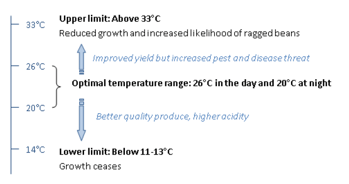
TEMPERATURE
The optimal temperature range should be between 20°C - 26°C as shown in the diagram4. Some variation in temperature is necessary for processes such as for stimulating flowering. However, prolonged variation outside of this range will prohibit good vegetative growth. Warmer temperatures lead to accelerated ripening and reduced beverage quality. Upper limit refers to daytime.
WIND YIELD
High winds have an adverse effect on growth because they can cause excessive tree breakage and increase the demand for irrigation. Therefore in especially windy areas it may be desirable to include “windbreaks”. See section 8.4 for more information on ‘windbreaks’.
ALTITUDE
Altitude will generally affect the temperature and amount of rainfall in the area and should be between 900m and 2000m. Ideally, the land will lie between 900 m and 1,250 m. At high-lying land, and therefore colder temperatures, a warmer North/North-West aspect is often preferred whilst on low-lying, and hence drier land, a cooler East/South-East aspect is more desirable.
RAINFALL AND HUMIDITY
Rainfall should be between 1,100-2,000mm. Coffee prefers humid (above 50% at 1400hr) to dry conditions and therefore more than 1,100 mm of rainfall is required per annum. However, with more than 2,000 mm each year the plant may be too cold and wet for spraying or be attacked by different fungus.
Note:
The water requirement and availability must be determined before there is a commitment to grow coffee
The potential coffee land should be situated as close to a reliable water supply as possible in order to ensure the possibility of irrigation remains viable.
Shade trees can also be used to improve humidity levels. See section 8.5 for more information.
SOIL AND LAND
Ideal conditions for soil and lands, in order to achieve optimal coffee growth, require:
Free draining and free of any restrictions to root development down to a depth of 1m.
Sandy loam/clay: Too sandy and it will require irrigation and additional nutrition. Too clay based and it will require drainage.
Good aeration: A slope of less than 15% is ideal. Gradual slopes provide the best form of frost prevention and “barrier” trees to cold air can also help.
Good soil fertility: The topsoil (30cm upper layer) should be rich in organic matter as it is this layer that the large majority of feeder roots are located.
High moisture holding capacity: 10-14 mm water/10 cm soil depth.
Slightly acidic soil with a pH between 4.5 and 5.5.
Moderate temperature: This can be regulated using a mulching process as well as planting shade trees.
LAND MAPPING
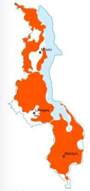
Rainfall Map of Malawi
Data source: Malawi Department of Climate Change and Meteorological Services
Rainfall between 1100mm and 2000mm per annum
The rainfall map below of Malawi displays all areas that fall within the specified ideal annual rainfall limits.
It can be observed that there is adequate rainfall over much of Malawi. The Blantyre, Thyolo and Mulanje districts form one such area in the South East of the country. The Zomba and Mangochi districts are also highlighted as featuring appropriate rainfall conditions while further west there is adequate rainfall to be found from Mwanza district through Ntcheu and up to Dedza.
In the central and northern regions of Malawi there is a consistent area on the western shore of Lake Malawi from Nkhotakota up to Karonga and inland to include Rhumphi and Chitipa. There are also small areas in the Mchinji and Lilongwe districts that are highlighted as having appropriate rainfall conditions. Areas that get winter rain have higher potential.
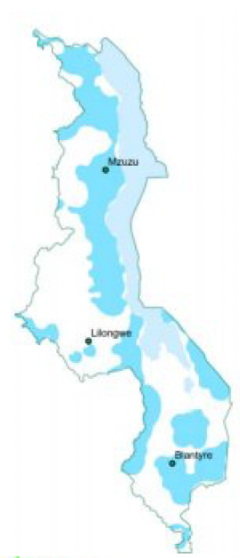
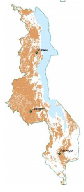
Altitude Map of Malawi
Data Source: Harvest Choice interactive data query (USAID)
Altitude between 900m and 2000m above sea Level
The altitude map of Malawi displays all areas in the country that fall within the ideal altitude band for growing coffee.
It can be seen that a large proportion of the northern and central regions of the country fall within the ideal growing zone in terms of altitude. The exceptions being the low altitudes around the lake and the high altitudes on the Nyika Plateau.
The southern region features less suitable areas in this regard. Appropriate regions can be identified in a large area from Thyolo to Zomba, a belt from Mwanza to Dedza districts and the Mangochi Highlands. The highlighted area around Mt. Mulanje is deceptive in that it mostly features the lower slopes of the mountain itself (which is a forestry reserve)
Temperature Map of Malawi
Data source: Malawi Department of Climate Change and Meteorological Services
Max 32°C & Min 13°C
The temperature map of Malawi displays all areas that fall between the upper and lower temperature limits for coffee growing.
It can be observed that most of the country falls within the limits specified for coffee growing. The only region that features temperatures that are too high is the lower shire valley and a narrow band around the shores of Lake Malawi. The remaining regions that have not been highlighted have recorded temperatures below the minimum threshold in winter.
Soil Map of Malawi
Source: Food & Agriculture Organisation (FAO) Soil Database
4.5<PH<5.5, over 1m deep, well drained
The soil map of Malawi highlights all areas that feature soils of appropriate depth, PH and drainage for coffee growing.
It is apparent that much of the southern region of malawi is unsuitable in this regard save for a relatively narrow region stretching from Thyolo through to Zomba. The highlands of the Mangochi district feature another area which is highlighted as having appropriate soils. Adequate soil conditions can also be found in the south west from Mwanza through to Ncheu.
The central and northern regions feature a greater area of appropriate soil coinditions with the exception being the regions around the lake and certain river systems on the western side of the country.
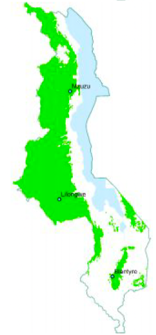
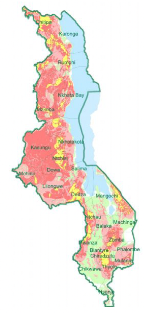
Map of Optimal Growing Areas in Malawi
Ideal Rainfall, Altitude, Temperature & Soil
3/4 Conditions met
2/4 Conditions met
1/4 Conditions met
Combining the four parameters reveals the ideal growing areas for coffee in Malawi. (areas in Yellow/Gold)
The Blantyre, Thyolo, Zomba and Mangochi and districts are currently coffee producing areas in the south. The area to the west from Mwanza to Dedza and Salima is also highlighted as an ideal area.
The central region features a large region around Ntchisi and Nkhotakota which is suitable. As well as a small band in the Mchinji district.
All of the northern districts indicate areas which are ideal for growing coffee with a particularly significant section identified in Chitipa. Coffee is currently being grown over many of these areas.
Many of the ideal (gold highlighted) areas are currently coffee producing regions. Farmers looking for new areas with potential should also consider the places that satisfy three of four parameters, particularly those that are adjacent to the ideal areas.
ADDITIONAL CLIMATE PARAMETERS
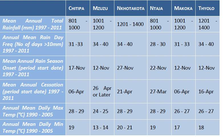
Table 1 displays additional Malawi meteorological data from stations are closely situated to key coffee growing areas. Coffee producers are encouraged to take note of important variables such as average number of rainy days, and the average onset and cessation of the rainy season.
Please note that this data represents historical trends and it is possible that future conditions will differ.
TABLE 1. ADDITIONAL CLIMATE INFORMATION AROUND KEY GROWING AREAS
CLIMATE CHANGE
Climate Change is one of the major challenges affecting the agricultural sector in the next 50 years. The International Panel on Climate Change (IPCC) estimates that it is ‘extremely likely’ that greenhouse gas emissions are changing the world’s climate. The term ‘global warming’ is often used to describe this effect but the implications for local climates can be variable. The impact of continuously increasing concentrations of greenhouse gasses in the atmosphere is likely to be significant in Malawi.
CLIMATE CHANGE & CLIMATE MODELS
Scientists have attempted to predict the impacts using Global Climate Models (GCMs). Using these models the future climate conditions are estimated and projected based on different emissions scenarios. These models are relatively skilful at producing large scale global weather patterns but become more uncertain when applied to a local scale. It is important to understand that there is a degree of uncertainty in these projections at a local scale. However, this does not mean that science is uncertain about the fundamental physics behind greenhouse gasses and climate change at a global scale.
CLIMATE CHANGE PROJECTIONS
The Malawi climate projections for the 2020-2040 period (using a high emissions scenario - RCP 8.5) are largely uniform across the country:
Later start to the rainy season
Higher rainfall during mid-season
Earlier cessation of rainy season
Increases in mean and extreme temperatures in October and November
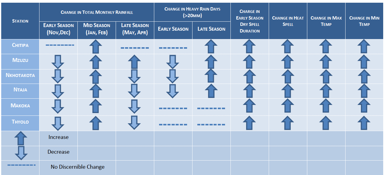
Climate projections for the 2040-2060 period (using the same emissions scenario) are more variable and conditions for stations near key coffee growing areas can be observed in Table 2. The general trends for this period can be summarised as follows:
Decrease in monthly rainfall in the early parts of the rainy season (including December)
Increase in the length of the dry spell during the early parts of the rain season
Increase in mid-season rainfall (Jan – March)
General increase in temperature, particularly before rains and during early rainy season
Most stations indicate a decrease in rainfall at the end of the rainy season
Less heavy rain days (>20mm) during early season and more heavy rain days during late season
IMPLICATIONS
The implications of climate change for coffee growing are numerous. The erratic rainfall and projected shorter season increases the importance of irrigation and soil moisture conservation methods. Increasing temperatures will likely see a change in the ideal altitude band for growing coffee with higher altitudes being more favourable. The higher frequency of storm events would have implications for suitable planting areas, increasing the importance of wind breaks and field drainage and design. The risk of growing coffee in Malawi increases but steps can be put in place for mitigating the risk.
TABLE 2. PROJECTED CLIMATE CHANGE FOR THE SUMMER RAIN SEASON PERIOD: 2040-2060. (RCP 8.5)
Source: Climate Systems Analysis Group for USAID Vulnerability Assessment (2013)